Innovations

Research collaboration
CNRS / University of Strasbourg / IPGS (UMR 7516)

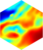
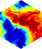
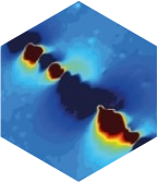
TERREMYS is involved in a research collaboration contract with the Institut de Physique du Globe de Strasbourg (UMR 7516) to implement a measurement, processing and interpretation chain for magnetic data acquired by drones.
This chain aims to develop and improve efficient and state-of-the-art acquisition methods through theoretical and methodological research.
The commercial offer of compensated UAV measures is a first.


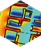
The magnetic compensation of the UAV
Oil & Gaz, Geothermal
Quarries & mines
BPW & buried grid
Archaeology

New application perspectives


Our LUMS technology innovates by reducing data acquisition costs and providing new application possibilities for all measuring heights between the ground and 150 m.

–The solution to acquisition constraints

The drone vector makes it possible to carry out surveys that until now could be slowed down by constraints related to topography and/or surface condition:
– slopes too steep for monitoring by plane or helicopter
– ground surface progression impossible

– New measurement scales

The UAV vector fills the gap between the ground and air surveys, opening up a new approach to missions.
The flight capabilities from 1 m to 150 m make it possible to fine-tune the surveys according to the desired level of detail, which depends on the flight height and profile density.
Thus, this concept opens the way to multi-scale surveys on the same project.

Our fleet

If you need any further information,
contact us

Studies

Flight path

Surveys

Data processings

Data delivery